There are three main types of fire in Fiji. Sugar cane farmers burn their fields to facilitate hand harvesting. Village farmers clear forest plots, fallow fields, and secondary vegetation for diverse crops using fire. And finally, the fires that cover the most ground are those set in the grasslands of the drier, lee-side of the islands. And of course there are occasionally fires that cause trouble – late last year I saw a major fire burning through the pine plantations in southeastern Viti Levu.
-
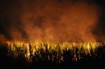
- Sugar cane burns at night south of Nadi, Fiji
-
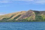
- Fire scar from grassland fire, southeastern tip of Vanua Levu, Fiji
-
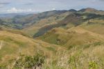
- Uplands in the centre of Viti Levu (Fiji): a pyrocultural landscape
-

- A grassy hill burns at dusk on village land, southeastern tip of Vanua Levu, Fiji
-

- Farmer heading to his fields with fire stick, Tailevu, Viti Levu
-
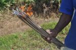
- Close up of fire stick


 Posted by christiankull