Like over a million (!) other viewers, I was captivated by the recent video “What’s inside this crater in Madagascar?” by Christophe Haubursin on Vox. Curiosity, satellite images, internet, a budget for a talented local filmmaker, and excellent production allow the team to explore why a village appears out of nothing fifteen years ago inside a remote broad, circular mountain in central Madagascar. Having spent days and days poring over historical air photos and maps of highland Madagascar for my own research, I palpably felt empathy for Haubursin’s landscape voyeurism. Then imagine my excitement as I realised I’ve been there myself, almost at the village site, on the southern summit of the mountain Ambohiby, in 1999, before it was built!
In this post, I’ll do two things: comment on some photos from my 1999 climb of Ambohiby, and give some leads for people looking to read further on the colonisation of empty lands in highland Madagascar, as I have been researching the settlement of new lands by Betsileo farmers since my masters thesis fieldwork in 1994.
The main story in Haubursin’s film, in addition to the explanation of the mountain’s 90 million year volcanic history, is why people chose to establish a village in a remote spot inside the circular mountain range. Available water, good soils, and open space are the answer, matching a long-held pattern. The old man filmed by Lalie Rabeharison and her team talks about “tany malalaka“, open or free land, that drew his family and friends here. They are Betsileo, from Manandriana, continuing a long tradition of outmigration from a densely settled region in the central highlands to the open lands of the “Moyen-ouest”. In doing so, they follow a long-established pattern of farmers transforming landscapes – first via fire and grazing into vast pastures, and later via spades, shovels, axes, and seedlings into settled ‘farmscapes’. I described these patterns, using the terminology used by farmers themselves, of how farmers ‘save’ open land by turning it into productive cropfields, in a book chapter (available here) from which the Figure below is drawn.

The farmers in the video have established a beautiful citrus orchard, building on a tradition of growing these cash crops in their home region not far from the city of Ambositra. Already in 1999, I heard of Betsileo establishing orange and clementine orchards in the Moyen-Ouest. These patterns of migration, crop field expansion, market cultivation, were a key theme of the research of geographer Jean-Pierre Raison (1937-2016), who led the geography program at the University of Antananarivo in the late 60s and early 70s, and those who followed him, including Herve Rakoto Ramiarantsoa (1954-2015) and Chantal Blanc-Pamard, who artfully document the care and artisanal skill of Malagasy farmers. For my own masters thesis in the 1990s, I re-studied several of Raison’s field sites, including a Betsileo village called Laimavo specialised in orange cultivation, where the population stayed the same over the decades due to out-migration to open lands either uphill or out West (see this 1998 article I wrote from the thesis, or this blog from a student field trip there in 2018).
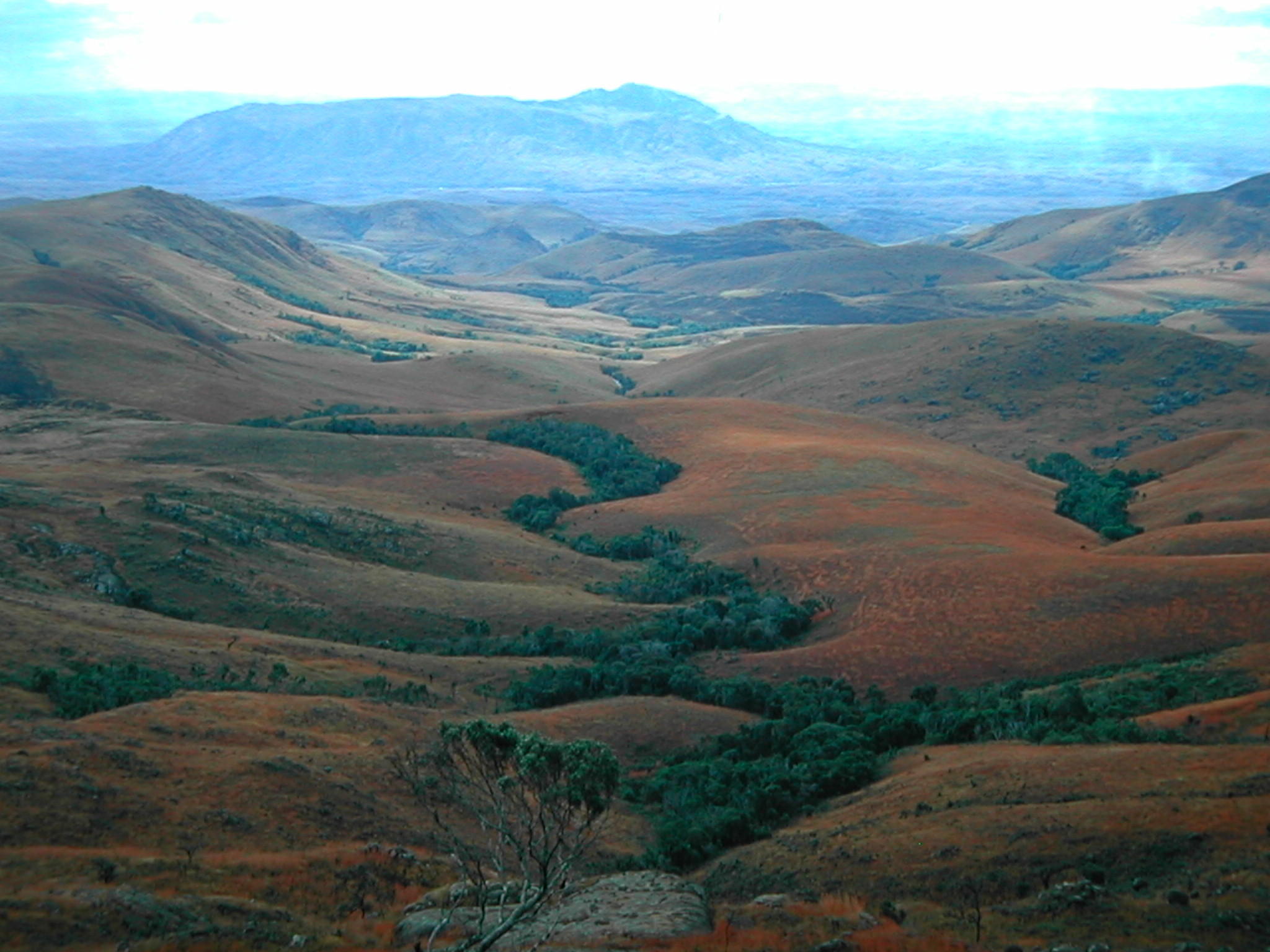
Climbing Ambohiby – on Sunday July 11, 1999 – was a weekend recreational excursion after a week of my doctoral field research on fire practices in a village near Tsiroanomandidy (one that Jean-Pierre Raison had researched and mapped in the late 1960s and I had studied in 1994). I went with forestry student Gidehona Randriamboavonjy and several volunteers from the French agricultural development aid organization AFDI we had met in Tsi’didy. We climbed directly, steeply up a trail that served as a chute for dragging trees cut out of the mountain forest, then higher up climbed straight up a stream bed, over cascades, and on through brush, grass, and forest islands – real technical bushwacking – to the summit of the mountain, where there was a large ancient tomb. Hundreds of pesky black flies or midges (mokafohy) bothered us the whole way. The views from the top were of beautiful pastures in all directions. And closer, there were multiple forest fingers, in various stream hollows, ravines, in patches on the summit, and especially in the south-facing bowl west of the main summit. This big forest had both deciduous and evergreen trees. Above 1500m the plants were covered in lichen, mosses, including the spiny rock-growing plants. All of the forests showed heavy signs of usage, tree cutting, and attacks by fire – quite heavily degraded. Nonetheless, we saw from far some white and black big lemurs (tsibahaka; Propithecus verrauxi deckeni) in the trees. There were cattle tracks and droppings all over.


The landscape has certainly evolved since I visited. From satellite imagery, much of the forest seems to have been lost, especially the riparian bits in my first picture above. I doubt the lemurs are still there. As I described in another article on land cover change in highland Madagascar, crop fields, orchards, and woodlots have often replaced riparian wetlands and forests, as well as grasslands, just as the farmers of Anosibe Ambohiby have done.
Haubursin’s excellent video opens up many more questions. I’d love to learn more from the farmers of Anosibe Ambohiby – how did they negotiate access to the land with nearby villagers and the cattle grazers used to free rein in the crater grasslands? How do they manage the free-burning pastures fires that must annually come close to their new orchards? Do they have connections to a trustworthy citrus merchant who regularly buys their oranges and lemons? And finally, what is the impact of their new-found internet fame? Will it bring more settlers seeking out the volcanic soils and plentiful water? Will it bring government services or the tax man? Will it bring dahalo cattle rustlers and thieves?
Articles cited above:
Raison, J-P (1984) Les Hautes Terres de Madagascar et leurs Confins Occidentaux. 2 vols. Paris: Editions Karthala.
Kull, CA (1998) Leimavo revisited: agrarian land-use change in the highlands of Madagascar. Professional Geographer 50 (2):163-76.
Kull, CA (2008) Saving land with a spade: human landscape transformations in the Madagascar highland. In Greening the Great Red Island: Madagascar in Nature and Culture, edited by Kaufmann, JC. Pretoria: Africa Institute of South Africa, 113-35.
Kull, CA (2012) Air photo evidence of historical land cover change in the highlands: wetlands and grasslands give way to crops and woodlots. Madagascar Conservation and Development 7 (3):144-152. dx.doi.org/http://dx.doi.org/10.4314/mcd.v7i1.7.


wow a very footprint of yourself at the crater….your adventure was amazing !!! these picture are amazing, hearing from the video that there was a dense forest and seeing your photos made me realized how more amazing it was on your time ♥ this is timeless
Has me wondering if some super wealthy survivalist will research the area and discover it may weather a nuclear holocaust, Survive a new global flood or ice age or even severe global warming. If so, I would not be surprized to se a huge agricultural survival complex built in proximity to the village with a runway or at least a helipad to have quick access from the Islands Ivato International airport. Complete with warehoused supplies, seeds, fertilizer and equipment to create a self-sufficient oasis. It could employ locals to gaurd, maintain and develop orchards and gardens along with some animal husbandry. An emergency fly-in escape home to ride out the end of an apocalypse and begin the repopulation of Earth after the colapse of civilization. Perhaps I should write a science fiction book about such an occrance and sell the movie rights to Hollywood. Then I may be rich enough to make it a relaity. LOL!